149
149
Dec 10, 2012
12/12
by
KOFY
tv
eye 149
favorite 0
quote 0
dropping down to 40 degrees in livermore. you'll see low 40s, fremont, py and santa cruz, san jose 45 degrees. upside to the chilly morning, it will be a beautiful day in the afternoon. high pressure will provide us a sunny above average day in terms of your temperatures for your monday. before we start to see the temperatures on tuesday, by tuesday night, rain develops 11:00 p.m. north of santa rosa as the night goes on we're going to start to see the rainfall across the heart of the bay area at 3:00 a.m. 5:00 a.m. rush hour, it does not look good for wednesday morning. scattered showers behind the system. by 7:00 a.m. in the north bay getting a break. it real continues through night. rainfall totals at this point look like generally a quarter to a half an inch at most. highs for the monday, 65 in campbell. santa clara and san jose. 66 degrees a mild day on the peninsula. 64 redwood city. half moon bay on the coast. daly city san francisco all 63 degrees. it's going blue skies, mild weather with an offshore flow. downsloping
dropping down to 40 degrees in livermore. you'll see low 40s, fremont, py and santa cruz, san jose 45 degrees. upside to the chilly morning, it will be a beautiful day in the afternoon. high pressure will provide us a sunny above average day in terms of your temperatures for your monday. before we start to see the temperatures on tuesday, by tuesday night, rain develops 11:00 p.m. north of santa rosa as the night goes on we're going to start to see the rainfall across the heart of the bay area...
273
273
Dec 25, 2012
12/12
by
KOFY
tv
eye 273
favorite 0
quote 1
. >> amazing demonstration of skill and courage saved a man's life in livermore. last night a 58-year-old man was stranded when creek waters rose to the top of his pickup. this was near del israel regional park. swimmers couldn't make headway in the water sought chp called in air support. the pilot actually put the hospitaler skid on the top the of the truck to stabilize his vehicle. the man was pulled into the chopper taken to the hospital and treated for hypothermia. amazing work by rescue authorities. >>> and the search for suspected drunk driver who jumped no a canal to escape police now called off. it happened early this morning in the city of ross near the college of marin. police made a traffic stop for possible dui but the driver took off on foo foot. officers chased him along the canal until they saw him jump in. search this morning produced no sign of him. police don't know if that means the man is dead or if he escaped alive. >> well in the east bay down trees and mud slides prompted road closure and crew in full clean up mode while still dry. nick smit
. >> amazing demonstration of skill and courage saved a man's life in livermore. last night a 58-year-old man was stranded when creek waters rose to the top of his pickup. this was near del israel regional park. swimmers couldn't make headway in the water sought chp called in air support. the pilot actually put the hospitaler skid on the top the of the truck to stabilize his vehicle. the man was pulled into the chopper taken to the hospital and treated for hypothermia. amazing work by...
95
95
Dec 17, 2012
12/12
by
KOFY
tv
eye 95
favorite 0
quote 0
livermore, 57 degrees. rain increases as cold front moves across the bay area tomorrow morning. it will be wet for the morning commute and as we look out towards the rest of our workweek stormy conditions. thursday, big storm into friday and possibly into saturday. here is a look at that cold front right here is the leading edge. a lot of cold air, once this moves in, all this cold air will move in and we're talking freeze as we head into tuesday morning. wednesday morning. this is how it is for 5:00 a.m. tomorrow morning. front will spread rain across the bay area while you sleep tonight. 5:00 a.m. commute time, wet pavement across much of the bay area. as we head into the 9:00 a.m. it will push toward the south bay. north bay will start to see breaks in the overcast. by 1:00 through 5:00 hour we will see clearing. we will start to dry up a bit. if you are traveling to the high country, close to a foot of snow is expected near lake level. lake tahoe has a winter weather advisory until 10:00 tomorrow evening, one to two feet. chain controls most definitely will be in place. lows
livermore, 57 degrees. rain increases as cold front moves across the bay area tomorrow morning. it will be wet for the morning commute and as we look out towards the rest of our workweek stormy conditions. thursday, big storm into friday and possibly into saturday. here is a look at that cold front right here is the leading edge. a lot of cold air, once this moves in, all this cold air will move in and we're talking freeze as we head into tuesday morning. wednesday morning. this is how it is...
238
238
Dec 31, 2012
12/12
by
KOFY
tv
eye 238
favorite 0
quote 1
we have 48 in san francisco. 41 in livermore. 41 in san jose and los gatos checking in at 42 degrees. here it is. a cold overnight forecast for you. look for inland frost in the north and east bay locations. we'll go with sunshine and scattered clouds for new year's eve. it will be a cool day and cooler night tomorrow night and bring out sunshine just in time for first day of the new year. satellite and radar composite, clear sky here although just to the north and west of us you can see the leading edge of clouds. this is what is going to move across the bay area by tomorrow afternoon. here is with a our anticipated lows. frost is likely and north and east bay protected valley areas. 39 expected in cloverdale and temperatures are dropping below the freezing mark. tender vegetation. if you have tender plants you may want to bring them in or cover them and do not forget about your pets outside, as well. 43 is expected low in san francisco and 35 for san jose. here is the cold front that will be draping across the bay area tomorrow afternoon. right now we'll put a few clouds in our accu
we have 48 in san francisco. 41 in livermore. 41 in san jose and los gatos checking in at 42 degrees. here it is. a cold overnight forecast for you. look for inland frost in the north and east bay locations. we'll go with sunshine and scattered clouds for new year's eve. it will be a cool day and cooler night tomorrow night and bring out sunshine just in time for first day of the new year. satellite and radar composite, clear sky here although just to the north and west of us you can see the...
125
125
Dec 11, 2012
12/12
by
KOFY
tv
eye 125
favorite 0
quote 0
clear sky right now chilly in some sports. 45 degrees at nap a.46 at santa rosa. 47 at fairfield. 48 livermore. 49 los gatos so it's a chilly night in many of our inland locations. rain tomorrow night into wednesday morning. snow is possible above 3500 feet some of the higher bay area peak and cold frosty couple mornings coming our way on thursday and friday. satellite radar composite image shows high pressure under control of our weather at the moment but cold front is advancing rapidly in our direction bringing down very cold air mass through the gulf of alaska and rainfall snow levels in the bay area 3 3500 feet so could be a flake or 2. snow flake. 8:00 o'clock tomorrow night by 11:00 o'clock tomorrow night see rain touching most of the bay contrary that pattern will tip overnight into the early morning hours by 5:00 o'clock wednesday morning start of rush hour will see showers around and some areas of rainfall wet spots in the morning commute and showers will scattered showers will continue to trail l midday hours of wednesday and sort of taper off. also bit end of the day wednesday we se
clear sky right now chilly in some sports. 45 degrees at nap a.46 at santa rosa. 47 at fairfield. 48 livermore. 49 los gatos so it's a chilly night in many of our inland locations. rain tomorrow night into wednesday morning. snow is possible above 3500 feet some of the higher bay area peak and cold frosty couple mornings coming our way on thursday and friday. satellite radar composite image shows high pressure under control of our weather at the moment but cold front is advancing rapidly in our...
181
181
Dec 15, 2012
12/12
by
KOFY
tv
eye 181
favorite 0
quote 0
livermore down to 34 degrees. we see 35 in concord. morgan hill upper 30's palo alto san jose half moon bay so definitely getting cold. 40 in oakland. 44 san francisco. tomorrow afternoon snow possibility around the lake county area and hills there. rest of the region chilly with light rain upper 40's to the low 50's. here's look at the high for your saturday around the monterey bay with light rain chilly as well. two things you need tomorrow a coat or jacket. and umbrella. that's it. all right. it's a light rain event for your saturday. few showers north sunday then more rain into monday and tuesday doesn't look terribly impressive. break coming midweek and then more rain on friday. but no mainly storm at this point. >> that's knit nice thanks very much. >> well just ahead here. bay area students write let investigators santa. not for what they want for christmas. these letters are to help make wishes come true for some other children. what that's all about as 7 [ female announcer ] here's to a whole world of happier holidays. time to
livermore down to 34 degrees. we see 35 in concord. morgan hill upper 30's palo alto san jose half moon bay so definitely getting cold. 40 in oakland. 44 san francisco. tomorrow afternoon snow possibility around the lake county area and hills there. rest of the region chilly with light rain upper 40's to the low 50's. here's look at the high for your saturday around the monterey bay with light rain chilly as well. two things you need tomorrow a coat or jacket. and umbrella. that's it. all...
188
188
Dec 9, 2012
12/12
by
KOFY
tv
eye 188
favorite 0
quote 0
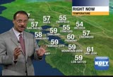
current temperatures, 43 in santa rosa. 53 in san francisco. 47 in livermore. 51 in san jose. our forecast, we'll go with patchy dense fog overnight. warming, you can expect the next couple of days and enjoy it because temperatures will sharply start to cool down as we head to mid-week. that is when the showers will return to the bay area, as well. lows tomorrow morning, it's going to be cold but maybe not near the freezing mark in the north bay. mid to upper 30s in most locations. 39 san rafael. 47 for san francisco. low 40s for the coast and san jose 41 and some low 40s mid to upper 30s. overnight tonight, we're going to get a northeasterly wind shift and some of that fog could migrate out back to the delta and north bay areas. keep that in mind, early travel tomorrow morning, reduced visibility in some locations. tom talk about next couple of days. high pressure starting to build in, it's starting to spill over and as it dominates tomorrow we will get into a slight wind shore component. and by tuesday this high will weaken that will allow moisture to move back in. here is a
current temperatures, 43 in santa rosa. 53 in san francisco. 47 in livermore. 51 in san jose. our forecast, we'll go with patchy dense fog overnight. warming, you can expect the next couple of days and enjoy it because temperatures will sharply start to cool down as we head to mid-week. that is when the showers will return to the bay area, as well. lows tomorrow morning, it's going to be cold but maybe not near the freezing mark in the north bay. mid to upper 30s in most locations. 39 san...
169
169
Dec 3, 2012
12/12
by
KOFY
tv
eye 169
favorite 0
quote 0
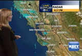
livermore 48. 51 in antioch. we're going to go with a few clouds overnight. it will be a cooler evening, a dry day for your monday and then the clouds will start to thicken up by tuesday returning to rain. especially in the north bay, a we head into tuesday afternoon. here is a look at lows tonight. remember, we'll on this lookout for some of that dense valley fog developing. we still have a lot of moisture out there. protected valley areas and temperatures will cool off. mid to low 40s in north bay locations. 49 in san francisco and oakland overnight. tonight 47 degrees. here is a look at radar composite and you can see the strong cold front that made its way right near the golden gate bridge around 7:00 this morning. then you can see just how quickly it started to press to the south and east. it is out of here. already you can see some of the high and mid-level clouds getting close to the bay area and advanced to the next system that will move in on tuesday. here is a look at the timing, north bay will see the most rainfall out of this system. this is 6:00
livermore 48. 51 in antioch. we're going to go with a few clouds overnight. it will be a cooler evening, a dry day for your monday and then the clouds will start to thicken up by tuesday returning to rain. especially in the north bay, a we head into tuesday afternoon. here is a look at lows tonight. remember, we'll on this lookout for some of that dense valley fog developing. we still have a lot of moisture out there. protected valley areas and temperatures will cool off. mid to low 40s in...
181
181
Dec 14, 2012
12/12
by
KOFY
tv
eye 181
favorite 0
quote 1
livermore, morgan hill. 33 degrees in fairfield. tomorrow thing preventing from falling way too low is the cloud cover. 41 in oakland. 40 san mateo o. 38 degrees. palo alto san jose santa cruz. here's a look at the satellite radar. this is a system another cold one coming in bringing us chance of some light rain on friday and really as new new computer model go by rain chance slimmer and lighte lighter. friday series of storms out here next 7 days. don't panic just yet. not all will produce a lot of rain. here's the deal tomorrow morning. clouds at 5:00 a.m. chance of few showers at 8:00 a.m. and then the shower chance pretty much into the early afternoon it's a hit or miss kind of shower. light tenth inch or less at most for your friday. we'll see more rain chance heading into the weekend and looking very light right now. chilly tomorrow afternoon. temperatures in the mid to upper 40's some of the coldest inland valley. low 50's right around the coast and bay lit rape is all we are expecting out of this system for your friday and a
livermore, morgan hill. 33 degrees in fairfield. tomorrow thing preventing from falling way too low is the cloud cover. 41 in oakland. 40 san mateo o. 38 degrees. palo alto san jose santa cruz. here's a look at the satellite radar. this is a system another cold one coming in bringing us chance of some light rain on friday and really as new new computer model go by rain chance slimmer and lighte lighter. friday series of storms out here next 7 days. don't panic just yet. not all will produce a...
125
125
Dec 20, 2012
12/12
by
KOFY
tv
eye 125
favorite 0
quote 0
it is going to get down to 26 degrees in fairfield. 28 degrees in livermore. 30 in vallejo. down to 28 in santa rosa. low 30s for fremont, mid 30s around san jose. definitely cold. you'll see the frosty lawns out there. 42 degrees in san francisco. this will be the last of the frigid cold nights. we have a slow moving storm and clouds coming in the temperatures will be hemmed up the next couple 6 days. this will be very slow mover. let me show you the computer animation, 1:00 p.m., just some clouds approaching the north bay. by 5:00 p.m. the rain line is north of santa rosa and around ukiah area, as we head into the overnight hours, friday morning, we start to get some rain. computer models are backing off on the intensity of the storm. we're still going with light to moderate rain at friday morning. 9:00 a.m. the front is moving through. we have just scattered showers behind it. at times it may be briefly on the moderate side. by 2:00 a.m. saturday, another band of heavier rain moving in. could see snow around lake county. that is the indication, cold nature of the storm on
it is going to get down to 26 degrees in fairfield. 28 degrees in livermore. 30 in vallejo. down to 28 in santa rosa. low 30s for fremont, mid 30s around san jose. definitely cold. you'll see the frosty lawns out there. 42 degrees in san francisco. this will be the last of the frigid cold nights. we have a slow moving storm and clouds coming in the temperatures will be hemmed up the next couple 6 days. this will be very slow mover. let me show you the computer animation, 1:00 p.m., just some...
218
218
Dec 13, 2012
12/12
by
KOFY
tv
eye 218
favorite 0
quote 1
just barely above freezing at cloverdale, livermore. many locations we'll see lows in the 30s. 42 in oakland and 38 at half moon bay. bundle up. satellite and radar composite image shows the cold front that brought us the cold air and now the big chill. coastal watch is still in effect. we have two more days of this. tomorrow and friday, reaching 7.2 feet. and 7 feet on friday morning and then things start to normalize a bit. we don't have major rain storms on top of the high tides. high temperatures tomorrow, mainly in the low to mid 50s much like today. a little chilly but its seasonally chilly. mid 50s. a degree or two milder to the south but not very much. here is the seven-day forecast. temperature range won't change much the next few days but a chance of showers on friday and frosty on saturday under sunny skies. chance of evening rain on sunday. chance of showers on monday. chance of showers lingering into tuesday morning. looks like a rainy day on wednesday. after a bit of chill we need to contend and then we'll go back to a rai
just barely above freezing at cloverdale, livermore. many locations we'll see lows in the 30s. 42 in oakland and 38 at half moon bay. bundle up. satellite and radar composite image shows the cold front that brought us the cold air and now the big chill. coastal watch is still in effect. we have two more days of this. tomorrow and friday, reaching 7.2 feet. and 7 feet on friday morning and then things start to normalize a bit. we don't have major rain storms on top of the high tides. high...
192
192
Dec 6, 2012
12/12
by
KOFY
tv
eye 192
favorite 0
quote 0
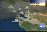
visibility is down just a bit in some locations, down to two miles at livermore, two miles at half moon bay as we are getting fog developing in some spots. these are forecast features, areas of fog developing overnight. mostly sunny days, turning milder and remaining mild for quite a while. here a satellite radar composite high pressure building in behind the frontal system that brought us dreary weather. this high pressure ridge is going to bring us nice sunny days but follow the time line. as some of the clouds move out, fog starts to settle in. areas of fog overnight and by the beginning of rush hour tomorrow morning, there will be reduced visibility in some areas. low temperatures will drop into the upper 40s in much of the north bay. right around or just about 50 in the remainder of the bay area. then tomorrow, sunshine. something we haven't seen for a while in the south bay. high temperatures in the low 60s. 61-62 in most locations up to 63 in los gatos. 62 palo alto and on coast. 59 in pacifica. downtown san francisco, a high of 60 tomorrow. 59 in the sunset district. north bay,
visibility is down just a bit in some locations, down to two miles at livermore, two miles at half moon bay as we are getting fog developing in some spots. these are forecast features, areas of fog developing overnight. mostly sunny days, turning milder and remaining mild for quite a while. here a satellite radar composite high pressure building in behind the frontal system that brought us dreary weather. this high pressure ridge is going to bring us nice sunny days but follow the time line. as...
113
113
Dec 8, 2012
12/12
by
KOFY
tv
eye 113
favorite 0
quote 0
livermore and danville. 61 at walnut creek and dublin and nont ray baylow to mid 60's up to about 65 and is a leap as 64 and holster and watsonville. accu-weather 7 day forecast. milder weather still on sunday and monday. mid 60's on the coast. mid 60's inland and upper 60's near 70 around the bay on sunday and monday. temperatures drop-off just a little bit on tuesday. chance of showers on wednesday and cooler pattern for the end of next week. all in all pretty terrific forecast. >> nice looking week. thanks very much. >> coming up next. riding high. and in style. thanking our best for serving our country yichlt someone took the jacket right off the back of a local congresswoman? stay with us. 7 news at 9:00 [ female announcer ] for those who love sweets, your season is here. let's just call it the baking time of year. you need special ingredients. you need the staples. that's a given. you need safeway sugar for just $1.97. and that magic thing that makes everyone want another -- only $2.99 for challenge butter. and when hands get messy, quite surely they'll say, "yum! wow! yay! wha
livermore and danville. 61 at walnut creek and dublin and nont ray baylow to mid 60's up to about 65 and is a leap as 64 and holster and watsonville. accu-weather 7 day forecast. milder weather still on sunday and monday. mid 60's on the coast. mid 60's inland and upper 60's near 70 around the bay on sunday and monday. temperatures drop-off just a little bit on tuesday. chance of showers on wednesday and cooler pattern for the end of next week. all in all pretty terrific forecast. >> nice...
124
124
Dec 29, 2012
12/12
by
KOFY
tv
eye 124
favorite 0
quote 0
further to the east it's qui society far in the livermore valley. union city fremont but you head west ward and through moss beach, definitely looking at that wet weather. slick roadway reduced visibility and santa cruz mountains notice here off the coast enhancement one of the spots we see maybe half inch of rain before it's all said and done. right now ems in the low to mid 40's. it was a chilly afternoon 46 right now in oakland 48 san francisco with low 40's over in antioch and fairfield. fairfield pretty gusty wind right now over 20 miles an hour. light rain tonight. some showers early tomorrow focusing around the south bay. santa cruz mountains. north bay clear out first. sfo level at around 3000 feecht we have seen rain and snow mix early this afternoon around ukiah and chilly day tomorrow and really cold start sunday morning but sunshine in the afternoon so here's the set up weak system offshore. area of low pressure will continue to travel down the coast throughout the next several hours and as it does it will spin up some rain into the bay
further to the east it's qui society far in the livermore valley. union city fremont but you head west ward and through moss beach, definitely looking at that wet weather. slick roadway reduced visibility and santa cruz mountains notice here off the coast enhancement one of the spots we see maybe half inch of rain before it's all said and done. right now ems in the low to mid 40's. it was a chilly afternoon 46 right now in oakland 48 san francisco with low 40's over in antioch and fairfield....
164
164
Dec 1, 2012
12/12
by
KOFY
tv
eye 164
favorite 0
quote 0
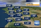
livermore pushing close to 2 and oakland got 2 inches of rain with more significant rain ming flash flood watch up through sunday evening. small streams may overflow the bank and here's a timing of the next storm. 9:00 p.m. it's north of santa rosa saturday night. at 11:00 p.m. it's still in the northern part of our viewing area as far as the heaviest part of the storm. heavy rain and wind coming through. 5:00 a.m. in the north bay sunday. it continues at 7:00 a.m. across the heart of the bay area. and really at 9:00 a.m. it's shifting south and east and we see sunny break sunday afternoon but when said and done rainfall total significant and more concerns to talk about. tell but those in a few minutes. >> sandy see you then. >> as expected the north bay saw the heaviest rain today. 7 news reporter laura has the story from petaluma. >> all the soil holding the water. >>reporter: leland says he has been down this road before. or at least his parking lot has. now submerge the in up to 2 and a half feet of water. >> the first place petaluma the only place that's left in petaluma. there's bee
livermore pushing close to 2 and oakland got 2 inches of rain with more significant rain ming flash flood watch up through sunday evening. small streams may overflow the bank and here's a timing of the next storm. 9:00 p.m. it's north of santa rosa saturday night. at 11:00 p.m. it's still in the northern part of our viewing area as far as the heaviest part of the storm. heavy rain and wind coming through. 5:00 a.m. in the north bay sunday. it continues at 7:00 a.m. across the heart of the bay...
109
109
Dec 18, 2012
12/12
by
KOFY
tv
eye 109
favorite 0
quote 0
you head out to livermore it was $700 of an fch of rain. over inch by wait in the santa cruz mountains. slight chance of tomorrow very flight get anything and freeding cold conditions coming your way with patchy frost by wednesday. show you the satellite and aid regardless. this is the storm that made for soggy morning commute. long gone and now we have colder air coming in behind it. the colder air associated with this upper level low is what is going to bring in a slight chance of a few light showers as we head into your tuesday. beyond tuesday active pattern thursday through sunday as couple storm systems are lined newspaper the pacific. show you computer animation. show you exactly what is going to happen. tonight 11:00 p.m. couple of clouds patch or 2 of fog. we head into 5:00 a.m. showers are just skirting the coast. this is the later computer model that upper level low stays parallel to the coast and so may bring in a shower or 2. doesn't look very likely but keep umbrella handy. may see mix of rain snow just north of ukiah. snow lev
you head out to livermore it was $700 of an fch of rain. over inch by wait in the santa cruz mountains. slight chance of tomorrow very flight get anything and freeding cold conditions coming your way with patchy frost by wednesday. show you the satellite and aid regardless. this is the storm that made for soggy morning commute. long gone and now we have colder air coming in behind it. the colder air associated with this upper level low is what is going to bring in a slight chance of a few light...
182
182
Dec 27, 2012
12/12
by
KOFY
tv
eye 182
favorite 0
quote 1
out towards livermore the mid 50s and down by the monterey bay temperatures fairly uniform. mid 50s there as well. here is a look at the accuweather seven-day forecast. so we will see the rain come in late on friday. much of it through the overnight hours into saturday. and then look at that, sunday looks sunny. new year's eve looking good. but you by middle of next week we could see a little bit of rain. looks like a more significant break coming our way. >> i like it. >> yes. >> thanks, lisa, very much. >>> just ahead, a mixup that brings good fortune. a small slip by a store clerk makes a family millionaires. we'll have that story. >> an act orwho plays a doctor on television wants to get into the coffee business in real ♪ [ female announcer ] no more paper coupons. no more paper lists. [ dog barking ] no more paper anything. safeway presents just for u. save more. save easier. saving more, starts now. just for u on the safeway app. tio2 he that has reached a settlement in a case involving hundreds of lawsuits over acceleration problems. an attorney says it is worth mor
out towards livermore the mid 50s and down by the monterey bay temperatures fairly uniform. mid 50s there as well. here is a look at the accuweather seven-day forecast. so we will see the rain come in late on friday. much of it through the overnight hours into saturday. and then look at that, sunday looks sunny. new year's eve looking good. but you by middle of next week we could see a little bit of rain. looks like a more significant break coming our way. >> i like it. >> yes....
237
237
Dec 4, 2012
12/12
by
KOFY
tv
eye 237
favorite 0
quote 1
chase began 3:30 this morning on 5 80 in livermore. officers closing in when the car overturned internorth flynn road on altima pass. officers suffered cuts and bruises as you can see here. 2 men eventually arrested when they surrendered near lathe respect and san what you keep county. >> one of 3 firefighters injured during crash in orinda going home today. doctor cleared michael rat this morning. he's home tonight. firefighters kelly morris still in the hospital and may need surgery for fractured leg knee and foot. steven pwroing requires surgery on his foot. all 3 firefighters were injured while responding to an accident on highway 24 early yesterday in the east bay. 2 vehicle could not stop and hit the fire engine. second vehicle rolled that the firefighters. fourth person was taken to the hospital and we understand is if critical condition tonight. >>> republic demands california are worried about the possibility of taxes going up because there aren't enough in sacramento to block it. lawmakers ushered in the new era today at the
chase began 3:30 this morning on 5 80 in livermore. officers closing in when the car overturned internorth flynn road on altima pass. officers suffered cuts and bruises as you can see here. 2 men eventually arrested when they surrendered near lathe respect and san what you keep county. >> one of 3 firefighters injured during crash in orinda going home today. doctor cleared michael rat this morning. he's home tonight. firefighters kelly morris still in the hospital and may need surgery for...

 Live Music Archive
 Librivox Free Audio
 Metropolitan Museum
 Cleveland Museum of Art
 Internet Arcade
 Console Living Room
 Books to Borrow
 Open Library
 TV News
 Understanding 9/11